Opening the event addressing global waste problems, Dr. William McIlveen gave an interesting look into how humans and their environmental impacts evolved over time. Loss of habitat and species extinction relayed a sense of urgency to take collective action regarding waste reduction. Although a pretty grim picture was painted, he ended on a positive note. There is something you can do about it. A more detailed account of the event can be found in this month’s newsletter. Esquesing Volume 54 Number 2 Listed below the photo gallery are the resources and links to the presentations and Display Board posters from our event.
“They’re not used to looking for a car or a truck coming”, says terrestrial ecologist. “If you happen to see a snowy owl, that’s just good fortune”, says Bruce Mackenzie of the Hamilton Naturalists’ Club.
On February 27, 2014, the International Joint Commission [I.J.C., 2014] released a report on the most recent algae bloom problem in Lake Erie. That report had much in common with a similar problem that existed in the Great Lakes about 50 years before. That problem was the association between phosphorus loading in the water column and the subsequent growth of algae, most conspicuously Cladophora glomerata, though blue green bacteria and other species constitute additional problems.
Figure 1. Cladophora on shore of Lake Ontario at Lorne Park, Mississauga, 1969. Photo from Mississauga Public Library collection.
Algae, like all aquatic organisms, are dependent upon the chemical constituent chemicals in the surrounding water. Generally, chemical concentrations in the water are quite dilute. As it turns out, the essential chemical that is most limiting for algal growth is phosphorus. As a result, small increments in the level of soluble phosphorus cause large responses in growth of the algae. When phosphorus levels in lake water increased up into the 1960s, excessive growth of algae occurred in the Great Lakes. The algae washed up on the shores of the lake (Figs. 1 and 2) where it began to decay and caused very unpleasant odors. Decaying algae consumes oxygen and when this happens in the aquatic environment, the eutrophic conditions with insufficient oxygen become limiting to many organisms including fish.
Figure 2. Cladophora on shore of western Lake Ontario 1969. Photo by W.D. McIlveen
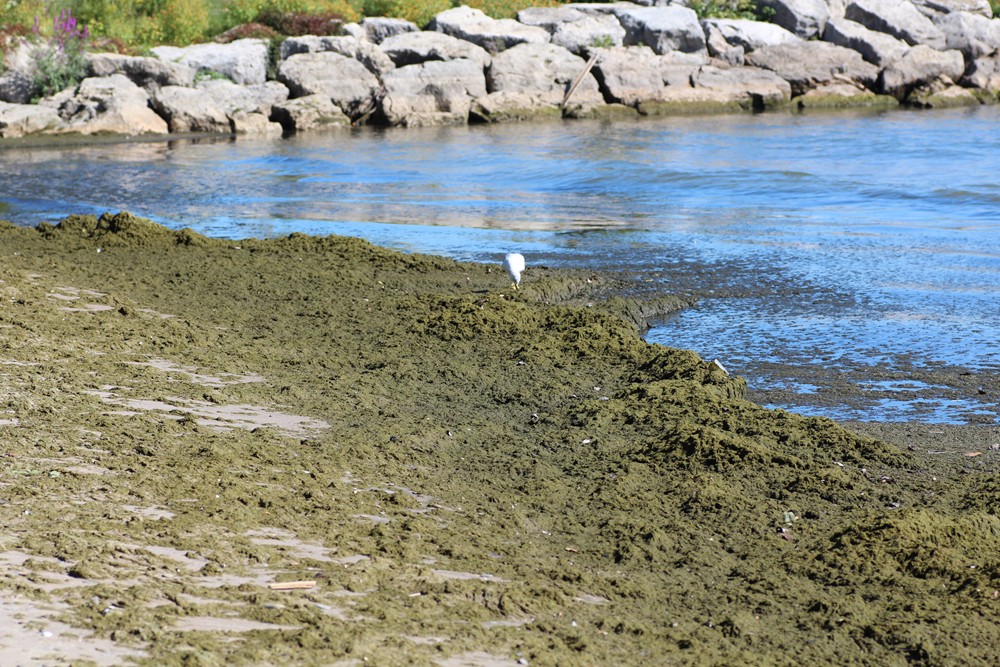
There were many sources of the phosphorus, however, the prime source was attributed to detergents used by human residents around the lakes [Schindler, 2008]. Despite fierce resistance from the soap and detergent industry, they were forced to remove the phosphate-based chemicals from their product by 1972. Following this, phosphorus levels in the water gradually declined and the algae problem generally improved. The removal of phosphorus from detergents did not permanently solve the problem. There was year to year variation in algae growth and the problem appeared in years of heavy growth (Fig. 3).
Figure 3. Cladophora on shore of Lake Ontario at Jack Darling Park, Mississauga, Sept. 11, 2011. Photo by W.D. McIlveen
Over time, the human population around the lakes increased further. Other sources of phosphorus grew including releases from sewage treatment plants. As well, new complicating factors appeared. Global warming caused earlier warming of the near-shore waters with the result that alga populations could become established earlier in the Spring. The appearance of the Zebra (Dreissena polymorpha) and then Quagga (Dreissena bugensis) Mussels made major changes in water quality. These species filter huge quantities of water with the result that water is made clear. With clearer water, light could penetrate to greater depths and this effectively extended the area over which the algae could attach and grow. More growth means more problems. Other introduced species such as the Round Goby (Neogobius melanostomus) and large populations of waterfowl that now feed on the mussels further complicate the picture.
In Lake Ontario, the water current in the western portion of the lake is generally counter clockwise when seen from above. This means that the currents along the shoreline off Peel and Halton are from east to west. The Halton shoreline is therefore downstream from any sources of phosphorus in Peel and the City of Toronto. In addition, the nature of the shoreline with piers and other structures influence the movement of the water and can cause floating algae to become trapped. Winds and storms can deposit, and remove, algae on the shore where it is an unwelcome caller in the minds of local residents.
The recent report by the IJC [IJC, 2014] has concluded that the most recent problem of algae in Lake Erie was mainly due to agriculture. This includes large animal production facilities and heavy use of fertilizers for crop production around the Lake. As well, residential use of fertilizers for lawns and gardens contribute a significant amount of phosphorus. The latter source was also confirmed in studies completed in Halton [Aquafor Beech, 2006]. These sources need to be addressed or the eutrophication problem will persist and grow. It is still too early to know what measures will be undertaken in coming years. Phosphate-free lawn fertilizer may be mandated for home-use for example. Conditions around Lake Erie must be altered or the algae issue will continue and grow. The so-called ‘dead lake’ state could return even though eutrophication actually represents a hyper-lively water body.
References Cited:
Aquafor Beech Limited. 2005. Final report prepared for Conservation Halton LOSAAC Water Quality Study. 127 pp.
International Joint Commission. 2014. A Balanced Diet for Lake Erie: Reducing Phosphorus Loadings and Harmful Algal Blooms. Report of the Lake Erie Ecosystem Priority. 100 pp.
Schindler, D.W. and J.J. Vallentyne. 2008. The Algal Bowl – Overfertilization of the World’s Freshwaters and Estuaries. University of Alberta Press, Edmonton. 323 pp.
There is little doubt that the winter solstice of 2013 will be one to remember for a long time to come. The situation was certainly not unprecedented for some freezing rain occurs in most winters. And the amount of rain that fell was less than that that which happened in the great ice storm of 1998 in Ontario. Yet the extent of area that was impacted and the number of people affected in 2013 might well be much greater. More time will be required for a proper assessment of the effects to be completed but the following is a preliminary set of observations from our area.
Fig.1 – Map of precipitation pattern in Ontario for December 20, 2013 from CBC News
The storm was not a single event but two similar storms that followed the same track about two days apart. As it turns out, our area fell zone where the ambient temperatures were too low for the precipitation to fall as rain and too warm to fall as snow. As measured at the Pearson Airport, the amount of rain that fell on December 20 was 8.6 mm followed by 16.6 mm and 13.6 mm on the two days following respectively for a total of 38.8 mm. The distribution of the rainfall as shown in the attached map obtained from the CBC weather forecast indicates that the highest amount of rain was expected further west of Toronto so it would not be unreasonable to expect that we experienced well over 40mm. By comparison, the amount of rain reported during the 1998 storm was 85 mm in Ottawa, 73 mm in Kingston, 108 in Cornwall and 100 mm in Montreal.
Fig. 2. Woods with ice damage, Nassagaweya-Esquesing Line north of Sideroad 15
The net result was an accumulation of a thick layer of ice on all exposed surfaces. The thickness on tree branches was observed to be at least 30 mm on the upper side surfaces. Considering the possibility of dripping, three dimensional distribution and multiple of layers branches, it is conceivable that the true amount of rain here was perhaps double that measured at Toronto. It appeared that the amount of damage above the Niagara Escarpment was greater than that at lower elevations.
The ice that accumulated resulted in a huge weight stresses on the tree branches. Although many factors are involved, the stress resulted in a great amount of branch breakage. It was estimated that about a quarter of the tree canopy in Toronto was damaged by the ice. Falling branches caused extensive damage to power lines and many support poles were broken. It took up to ten days to get all power restored. Fallen branches also blocked sections of roadways.
Fig. 3. Ice damage to willows, Dublin Line.
There are additional factors to consider including species involved and branching patterns of individual trees but two patterns were evident in the breakage. Large branches that broke were often suffering from some previous damage or decay, especially when the branch crotches were narrow. The second thing was the there were huge numbers of smaller branches that were broken, usually in the upper crown. The branches affected exhibited a reasonable consistency in diameter where the break occurred. This was at branch diameters of 6 to 10 cm. It seems reasonable to conclude that the wood strength at diameters greater than this were able to support the load of ice. At lower diameters, the individual twigs were flexible enough to withstand the ice. But at the indicated diameters, the branches supported a certain combination of number of twigs of a particular length such that the critical load-bearing strength of the supporting branch was exceeded and so it broke. A very similar pattern was evident in Eastern Ontario following the storm of 1998. When trees did not break, the trunks bent under the load. In some cases, species such as poplars and birch bent to a high degree, sometimes involving trunk diameters that were well in excess of what one might expect as possible.
Despite the obvious damage, especially where entire trees had to be removed, the long-term impact likely to be limited. Broken branches will undoubtedly reduce the rate of growth of the trees for a short period of time. It is to be expected that broken branches will create potential infection courts for decay to become established. Studies of this kind were initiated following the storm of 1998 but the results of those studies have not been widely distributed. When one travels through eastern Ontario, it is becoming increasingly difficult to see broken branches as the branches lower on the trunk have grown and surpassed the point of the break.
While we cannot say with certainty that a similar storm will or will not occur again in the near future, the possibility for such a storm will always remain. While it may be counter intuitive that an ice storm resulted from global warming, that may in fact be the case. Global warming is expected to alter the frequency and severity of storms but storms can occur in all seasons. It will not be possible to attribute any individual storm to climate change. All we will be able to do is observe that more storms occur and deal with them as they arise.
Earlier this Spring on two successive days, I was driving along our gravel road and noticed a ‘dust devil’ at the same location each time. I am sure that everyone has seen such things at some point in their lives. Seeing one is not at all unusual but noting two in the manner that they occurred prompted me to prepare this little note.
The conditions that must exist to form the dust devils will likely occur many times but they remain invisible. We only see them when they cause fine dust, leaves, paper and similar light materials, rarely snow, to be swept up into a circular funnel. Without the telltale visual evidence, we pay no attention for we simply cannot detect them. Similarly, we seldom have the opportunity to photograph them. They typically only last a few seconds so unless we have a camera already at hand, we don’t get a fair chance to document their existence.
Dust devil photographed at Lake Bogoria, Kenya, 2001 (Photo by W.D. McIlveen)
In many respects, they are like miniature tornados with a spinning vortex. ‘Whirlwind’ is a fairly good description. They may be as small as meter wide and ten meters high to rare ones that might be ten times as wide and one hundred times as tall. The motion is nearly always upwards in the form of a swirling updraft under sunny conditions during fair weather. A basic requirement is that there are areas with a differential in heating of different air pockets. The devils form when hot air near the ground surface rises quickly through a small pocket of overlying cooler, low- pressure air. Under the right conditions, the air may begin to rotate. As the air rapidly rises, the column of hot air is stretched vertically, causing intensification of the spinning effect. A fully-formed dust devil is a funnel-like chimney through which hot air moves, both upwards and in a circle. Additional hot air rushes in toward the developing vortex to replace the air that is rising As the hot air rises, it cools, loses its buoyancy and eventually ceases to rise. As it rises, it displaces air which descends outside the core of the vortex. The spinning motion cause the dust devil to move forward. The upward speed of the air within the vortex has been reported to be at least 40 km/hr. On occasion, wind speed in the rotating air can reach as high as 120 km/hr.
Dust devils are most evident in flat terrain that lacks vegetation, or in fields, deserts, or tarmac. Such conditions favor the build-up of heat near the ground surface as well as the increase the chance that dust or sand may be swept up. Clear, or relatively clear, skies enable solar energy to easily reach the ground to warm the surface yet have cooler air above. Ambient wind needs to be very low or absent or else there would be too much mixing of the cooler upper air with the heated air at ground level. If two distinctly different air temperature regimes cannot be established, then a dust devil cannot form.
Somewhat similar vortices form in the center of large fires like forest fires where there is a rather obvious source of heated air and smoke. Vortices also occur in the lea of buildings that are exposed to winds, depending upon the size and shape of building and other characteristics of the surrounding environment. The latter are notably different in origin, arising from mostly lateral winds. The swirling motion can cause snow to form drifts and other debris to form circular piles on the downwind side of the structures. These materials fall to the ground in the centre of the vortex which lacks the air speed to keep the materials suspended.
Dust devils seldom cause significant damage or injury, simply because they are limited in size and do not last. On occasion, they might do limited damage if the particular conditions allow the wind speed to be unusually high. The wind movement could potentially move materials from one place to another and this may be undesirable from a human perspective. Dust might become entrained in the wind and this might be quite undesirable. They could cause the components of the dust or creatures nearthe ground surface (e.g. insects, plant pathogens, weed seeds) to become airborne and moved to new locations. Occasionally small rodents could be forcibly moved from one place to another. In general though, dust devils are mostly just fleeting visible indicators of the fact that our physical environment is constantly in flux.
by W.D. McIlveen
Halton/North Peel Naturalist Club
So far, the year 2012 has seen some disruptions in normal weather patterns. In March, we experienced some rather warm days that caused many wild flowers to appear early, foliage on trees and shrubs to emerge early, and for amphibians to start breeding early as well. This was followed by a relatively cool April. Then in June and July there were days with high temperatures and dry conditions. This report examines some of the impacts of those weather conditions on plants.
Temperature and water availability are two of the most important environmental factors that control the welfare of plants. When these are present at high or low values, then we can expect that certain stresses will start to occur or that the plants will perform at less than optimum growth rates. Not all plants will respond in exactly the same way for some are adapted for low temperatures while others prefer warmer temperatures for example.
The conditions that prevailed in the spring 2012 had major consequences for some crops, notably the McIntosh cultivar of apples. Specifically this was because of a frost or low temperature event at a critical time in flowering. As a consequence, the pollination rate was extremely low and little fruit was set. Other cultivars fared somewhat better. It is uncertain whether weather (i.e. frost) was the main factor but it was rather obvious that wild fruit loads on trees and shrubs through Northeastern Ontario were extremely poor and mostly zero by late this summer. A conversation with a wild blueberry seller confirmed that the blueberry harvest was extremely poor and pickers had a very difficult time finding enough fruit to collect and sell. Aside from the very high prices that could be commanded for the limited fruit that was available, it is easy to appreciate that wildlife such as birds and bears will have a difficult time finding food this year.
Figure 1. Ice and cold temperature injury to Alternate-leaved Dogwood, Acton, May 2, 2012
Locally, the effect of low temperatures in the early growing season did not appear to have significant impacts for native plants. Most native plants do retain some tolerance to short periods of low temperatures. Even at this, the young foliage on Alternate-leaved Dogwood showed a reddish-brown discoloration along the margins and between the veins. Reddish coloration often accompanies a physiological phosphorous deficiency that is induced by cold temperatures. This gradually disappeared as the growing season advanced. There was a small amount of acute necrosis of some Dogwood leaves but this only occurred where ice formed when rain runoff from the house roof froze on the foliage (Figure1).
Weather-stress conditions occurred later in the growing season in the form of drought. It was reported that the timing of the drought was particularly bad for corn producers. Although corn plants were widely seen to be suffering (leaves rolled up) in many parts of the Province, the plants remained alive for a long time. The yield though was impacted since the silks could not be pollinated during the critical short window when silks and pollen must come together. The overall effect was a low rate of pollination and this in turn will impact upon the amount of seed that gets set. The true impact can only be known after the harvest has been completed. It is expected that the price for corn for animal and human food will be quite high due to shortages in the crop through much of the corn-producing parts of North America.
Figure 2. Total monthly precipitation reported at Pearson Airport from March through July, 2012.
Figure 3. Monthly precipitation reported at Pearson Airport from March through July, 2012 excluding the rain events on June 1 and July 31
The reported monthly totals of precipitation for the study period (March through July) may be a somewhat misleading. As shown in Figure 2, the monthly totals at Pearson Airport for March, April and May are not much more than half of the normal amounts for each month. The amount for June is very close to average while that for July is about 30% above average. But timing is everything. Of the total of the 76.4 mm for June, nearly half (37.4 mm) fell on the very first day of the month. In July, the largest rainfall that measured (38.8 mm) fell in a thunderstorm on the very last day of the month. There were a couple of light rains on July 22 and July 25 but these were not even seen in many parts of our area. This means that there was an extended time (over seven weeks from June 2 to July 21) where practically no rain fell at all. In combination with some days with rather high temperatures, most plants without an irrigation source would have been subjected to some very severe drought stress. Figure 3 shows the same data as Figure 2 but the amounts of rain that fell on June 1 and after July 22 have been excluded to provide a more realistic image of the conditions that plants would have experienced. Some native plants in our area did exhibit symptoms of weather (drought) stress. Such symptoms included drooping of the foliage and later, complete drying of the foliage. (Figs. 4 and 5).
The normal growth of plants includes uptake of water from the soil and transpiration of that water through the foliage. When there is an inadequate supply of water, the plant has several responses to help cope with the shortage. A prime reaction is to close the stomates to reduce the loss of water through the leaves. While water loss may be reduced by this action, it also reduces the amount of nutrients that can be absorbed from the soil and transported to the leaves. Closure of the stomates reduces the amount of carbon dioxide that can be taken up to become involved in the photosynthetic process. Reducedtranspiration means that the foliage does not get cooled through evaporation of the water. As a result, the leaf temperatures get raised above optimum and so the plant cannot grow at an optimal rate. Overall though, it is most desirable to the plant to conserve the water it has, rather than grow large. To compensate for the lack of water, many plants will shed their excess foliage. This effectively cuts down on the total leaf surface that is transpiring at any given time.
Figure 4. Temporary wilting of foliage of Green-headed Coneflower due to drought
Hormones produced in the roots trigger the mechanisms that lead to abscission of excess leaves, much like the normal fall of foliage each Autumn. Stressed trees for example might show a high proportion of yellowed foliage (often older leaves and leaves lower on the stem. Another clue to the drought stress is an excess of recently-fallen foliage on the ground much earlier than would normally take place. Sometimes, totally dried or dead foliage will be retained on the branches.
Figure 5. Foliar necrosis due to drought stress on Wild Raspberry, Acton, July 25, 2012
Late in August, large patches of totally brown, necrotic trees and shrubs were seen in the area south of Parry Sound. This area has rather shallow soil soil and therefore the water reserve in the soil is quite prone to drought stress but the degree of stress in the summer 2012 in that area is the most severe that the author has witnessed in over 35 years. Whether or not the affected vegetation was killed outright will become known in 2013; however, there is little doubt that there will at least be a notable impact on the affected sites for several years to come. Locally, the stress observed will not likely have an observable enduring impact on perennial species but cumulative stress from similar conditions in future years could produce notable effects, likely as smaller plants with less flowering, lower seed set, or greater incidence of insect and disease attacks.
by W.D. McIlveen
Halton/North Peel Naturalist Club
Recently, one of the items covered by the news media was the change in distribution of various species owing to climate change. There are other causes for expansions of populations other than climate shifts but this discussion is limited to the global warming phenomenon. The media accounts included the recent appearance of fish species in the ocean much further north than where they normally occur. One species that was mentioned that has relevance to our own area was the Giant Swallowtail Butterfly.
Figure 1: Giant Swallowtail Butterfly adult, Prince Edward Point, May 30, 2009
While it is a good thing that the media covered this important story, they unfortunately got it wrong. To listen to what they were saying one was left with the impression the species involved were fleeing from excessive heat in their traditional areas and seeking respite in cooler areas. This is not the case. The geographic range expansion is possible only because the new areas are now offering conditions (slightly warmer) where the cooler conditions had prevented then from surviving before. Giant Swallowtails (Papilio cresphontes) are the largest butterfly in much of North America. Their wingspan ranges from 10 to 14 cm across! (Figure 1). They tend to stay in woodland areas or, in the southern US, in citrus groves. The adults sip flower nectar for food. The larvae of this butterfly are known as the ‘Orange Dog’, not for their colour but for their host in citrus groves. The caterpillars look a lot like bird droppings and can get as big as 4.5 cm long! (Figure 2)
They generally adopt a disguise by looking like bird droppings, an appearance that they retain until they pupate. Another deterrent to would-be predators is the osmeterium. This is a reddish, forked gland located behind the head that is extended when the caterpillar disturbed. The osmeterium exudes a fluid that is considered to smell terrible and deters any attacker.
Figure 2. Giant Swallowtail Butterfly larva on Common Hop-tree seedling, Windsor, September 6, 2011
In years past, Giant Swallowtails were essentially restricted to the far southern parts of the province. They would occasionally wander farther and one vagrant had been reported at Ottawa. Now they are much more frequent in parts of the province where they were seen only occasionally. How much of this recent range expansion is due to climate change is still unclear. Milder winters could certainly assist in the survival of the species over the coldest part of the year. A key limitation in their distribution is the availability of their host plants.
Hosts of the Giant Swallowtail all belong to the citrus plant family Rutaceae. We do not have many groves of oranges or lemons in Ontario to sustain the butterflies but we do have a few other members of the plant family. The list includes Gas Plant (Dictamnus albus), Cork Tree (Phellodendron amurense), Common Rue (Ruta graveolens), Common Hop-tree (Ptelea trifoliata) and American Prickly-ash (Zanthoxylum americanum). The first three mentioned are all introduced or non-native species. They are rarely grown and are thus hardly capable of sustaining populations of the butterflies in Ontario. The Hop-tree is rather uncommon in Ontario and restricted to the Carolinian zone. The main job of supporting the larvae of the Giant Swallowtails then falls to the Prickly-ash that has a much wider distribution than the others though it also tends to grow in more southern parts of the province. Prickly-ash is a relatively inconspicuous species that goes unnoticed unless one needs to cross through a patch of it. Then the thorns on its stems are more than adequate to grab the traveler’s attention. Other than vagrant butterflies that might be carried by the wind, the anticipated range of the butterflies is going to strongly mirror the distribution of Prickly-ash. Perhaps the changing climate will allow that plant to extend its range and thus allow the butterflies to follow further a field. It will be interesting to follow shifts in distribution patterns for these species as well as others that exhibit similar types of range restrictions.
by W.D. McIlveen
Halton/North Peel Naturalist Club
serving Brampton, Georgetown, Milton, Acton, Caledon & surrounding areas
Meetings are held at St Alban the Martyr Anglican Church
537 Main St,.
Glen Williams
On L7G 3T1


 “They’re not used to looking for a car or a truck coming”, says terrestrial ecologist.